
The surprise arrival of a package, containing a Red Nose Day T-shirt from my friend Dr. P.M. of Cambridge, reminded me that I have yet to write up the impressions from our medical history perambulations from February 2009. The idea was to try one or more of the walks described in Nick Black’s Walking London’s Medical History, take photos, and discuss the positive and negative aspects of the guidebook. For a variety of reasons, this did not go well for two distractible academic persons with diverse interests in British history, architecture, literature, social justice issues, and gardening … and no, not because I kept looking the wrong way and walking in front of buses and lorries (Dr. P.M. made sure I didn’t do that).
We decided to try Walk 3: A Cradle of Reform, starting at King’s Cross/St Pancras tube station. I believe you are meant to stand near the Euston Road exit and read five to six pages of rather small text, with information about infectious disease hospitals of the 19th century (e.g. London Fever Hospital, London Smallpox Hospital). This seemed likely to annoy other people, so we began walking towards the Royal National Throat, Nose, and Ear Hospital, founded by ENT surgeon Lennox Browne in 1874. There are four pages of rather small text on ENT hospitals and on the Royal Free Hospital, founded by William Marsden and originally located in the abandoned barracks of the Light Horse Volunteers on Gray’s Inn Road. The Royal Free Hospital was moved to Hampstead in 1974, and in its place is the expanded Eastman Dental Hospital.
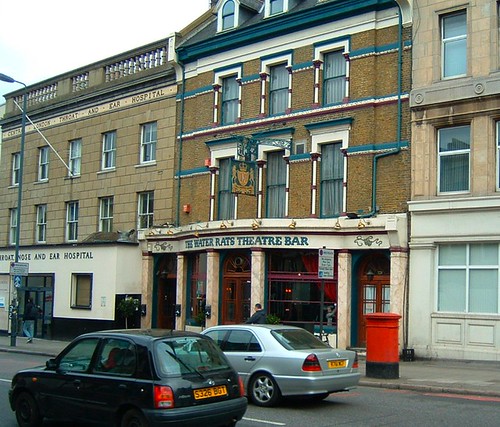
Royal National Throat, Nose, and Ear Hospital
Dental Hospital
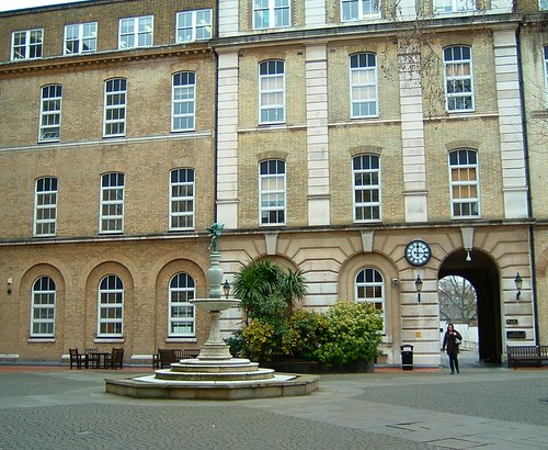
Bored yet? We were. But slightly encouraged by the next set of instructions, we crossed Gray’s Inn Road to enter St. Andrew’s Gardens, bordered in part by the former Alfred Langton’s Nurses’ Home, built by the Royal Free to house its nursing staff.
Entering St. Andrew’s Gardens
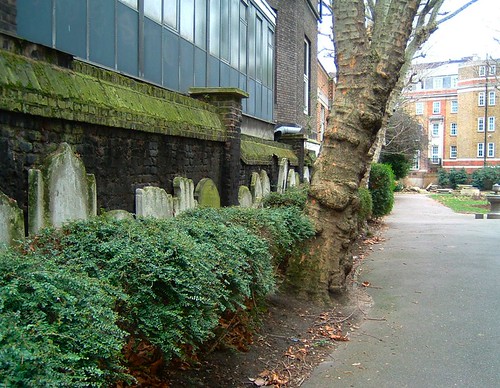
This lovely urban refuge, which used to include a graveyard, was established through the Vestry of St. Pancras, and contains a public drinking fountain that provided clean water for the poor in the 19th century. It merits only a short paragraph in the guidebook, which is unfortunate, as it sequesters well-maintained rose gardens, visually interesting stacks of old gravestones, and a connection to the community and history of everyday life in London.
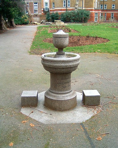
Public drinking fountain, St. Andrew’s Gardens

Old gravestones, St. Andrew’s Gardens
On to Calthorpe Street, and there were 22 more pages of photos and squintingly tiny text for this particular walking tour. Our enthusiasm for following the tour to the letter was waning, and there were many fascinating sidetracks and photographic opportunities. We had started to stray from the route described in the guidebook, and several of its negatives had become apparent to us:
1. The map for each walk is tiny, cross streets and sites of interest are not marked, and the page is difficult to access repeatedly (I would have added a sticky tab on the map page). There is no obvious distinction made between existing buildings on former medical use sites, hospitals, and actual medical sites still in use.
2. Even with two literate and possibly over-educated people, it was difficult to follow the map and the extensive text. I think an outline version, embedded with the map on two full facing pages (or on a fold-out) would work better; the detailed history could be presented elsewhere.
We continued to Coram’s Fields, which has an interesting social justice history that I’ll save for the next installment. And as foreshadowing for our getting completely off track, I’ll mention that we also walked through an urban community garden project and took photos there.
To be continued ….
Gah, shame you were saddled with a poorly thought-out guide book. Especially when this gem is available: http://www.medicallondon.org/
It’s not only a peerless guide to London’s medical history, designed to be walked, it’s also in my top 5 books about London ever…and I’ve read something like 200.
Definitely worth getting hold of when you’re next in London.
I think you had reviewed that one on your blog, around the time of my UK trip – I remember thinking it looked great, but I couldn’t purchase it in the US in early 2009. A friend of mine travels to London on business once or twice each year, so I’ll try to convince him to buy it. He’s also interested in medical history walking tours, but I can’t recommend the guidebook that I have; I wouldn’t even bother posting it to him for his next London trip. It *is* a shame, really, because I’m sure there’s a lot of fascinating history buried in all the verbiage. It just doesn’t work as a guidebook, I’m afraid, and Dr. P.M. and myself were probably inclined to be favorable before we started out.
Ah, London. I’m familiar with the “looking the wrong way and almost getting run over” issue, being a drive-on-the-right North American. I can also clearly remember seeing a postal van being driven by a dog on one occasion – before realizing that the dog was, in fact, sitting in the passenger seat!
Still, the concept of the medical history walk is a good one. Seems to me that this would be a perfect app for the iPhone, rather than a wordy, foldy-out paper guidebook. But this is 2011, and that was all the way back in early 2009, of course. 😉
When I returned to the US after three years in London, I experienced the perilous phase of looking the wrong way yet again. The danger was compounded by my habit of commuting by bicycle both in London, and upon my return to the US.
An iPhone app, or perhaps a Kindle or iPad version, for medical history walking tours would be excellent. Though I tend to like fold-out paper maps and guides, if they’re well-designed. Something like the 2-page “Annotations” feature in Harper’s magazine would be ideal.
I was gonna say exactly the same things about the iPhone app, and looking the wrong way, and cycling on the wrong side of the road. That’ll teach me not to read new blog posts right away.
Do you find cycling on the wrong side of the road to be more difficult than driving on the wrong side? I do, because once you’re sitting on the wrong side of the car, it actually feels natural to drive on the wrong side of the road, but you don’t get those visual cues on a bike.
So that’s what you were doing before/after Cromer Is So Bracing 2009!
You want a medical London iPhone app, you say?
http://londonist.com/2010/08/new_app_tours_the_gruesome_history.php
At first I thought it would be something like the London Dungeon, but that actually sounds excellent. As an anatomist, I think a little blood and gore liven things up.
Your Londonist logo is very sharp, M@ – are there T-shirts or hoodies available?
Thanks. We only changed the logo last week, to include London’s new Shard building. We keep saying we’ll do T-shirts one day, but we never get round to it.
I increasingly find text in guide books to be unreadably small. I do have reading glasses that I sometimes use but then I cant see where Im walking so it is tricky. I have bought a couple of guides for iPad but its not very convenient to carry it round in your hand.